

The Berg Lake Trail, in B.C.’s Mount Robson Provincial Park, showcases some of the best scenery in the Canadian Rockies. The 23 km / 14.3 mi backcountry route is a magnificent journey through deep valleys, along raging rivers, and past thundering waterfalls and glacier-studded peaks. Berg Lake, the star attraction, is a turquoise, glacier-fed lake that sits beneath towering Mount Robson. We just returned from our Berg Lake backpacking trip. There’s a lot of hype about this trail, but it exceeded our lofty expectations. What a way to celebrate the re-opening of travel in British Columbia!

A bench with a view at Berg Lake campground
The 23 km / 14.3 mi (one way) trail gains 800 m / 2625 ft. It is well-marked and in mostly excellent condition. There are seven campgrounds spread along the route providing options for beginner to expert backcountry hikers. Some people hike to Berg Lake campground in one go. This is demanding, especially with a heavy pack. Many people choose to split the ascent (and often the descent) into two days. We spent a night at Whitehorn campground, both on the way up and down, and three nights around Berg Lake (for a total of five nights). This unhurried schedule gives plenty of time for admiring the scenery and for day hikes near Berg Lake. Even if you’re fit and fast, I’d recommend spending at least three nights on this beautiful trail.
| Campground | Distance from Trailhead | Elevation | Number of Tent Pads |
| Kinney Lake | 7 km / 4.3 mi | 984 m / 3230 ft | 14 |
| Whitehorn | 11 km / 6.8 mi | 1097 m / 3600 ft | 22 |
| Emperor Falls | 16 km / 9.9 mi | 1615 m / 5300 ft | 9 |
| Marmot | 19 km / 11.8 mi | 1645 m / 5400 ft | 7 |
| Berg Lake | 21 km / 13 mi | 1641 m / 5385 ft | 26 |
| Rearguard | 22 km / 13.7 mi | 1646 m / 5400 ft | 5 |
| Robson Pass | 23 km / 14.3 mi | 1649 m / 5410 ft | 15 |
The description below is divided into trail segments based on the seven campgrounds.
Trailhead to Kinney Lake Camp:
From the trailhead to Kinney Lake, the swift Robson River is our constant companion. The trail is wide and mostly shaded with a gradual uphill profile. It passes through an impressive cedar stand and offers teaser views of Mt. Robson, the highest mountain in the Canadian Rockies.
At around 5 km we get to the south end of shimmering Kinney Lake, the first milestone of the hike. We find a killer picnic table for our lunch. The view over the idyllic lake to Whitehorn Mountain sets the bar high on day one.
Kinney Lake campground is another 2 km along the undulating terrain that hugs the east side of the lake. There, we find a pleasant, open-sided shelter with picnic tables and tent pads overlooking the lake. It’s a very appealing campground and would make a great destination for a relatively easy 14 km (return) day excursion if you’re not backpacking.

Robson River at the Berg Lake trailhead 
The first few kilometres of the trail are through a cedar forest 
Mount Robson looms in front of us 
Bridge at the south end of Kinney Lake 
Nice lunch spot at Kinney Lake
Kinney Lake Camp to Whitehorn Camp:
At the north end of Kinney Lake there is route choice: follow the main trail that rollercoasters up and down through the forest, or take a shortcut across the alluvial fan. We choose the latter on the way up to avoid unnecessary elevation gains. It’s a fun walk through the gravel and sand deposits with numerous little stream crossings. If water levels are too high, this shortcut may be closed. (On our return journey, we hike the forest route, and despite the hills, we appreciate the shade and the views.)
Beyond the flats, we reconnect with the main trail and it’s a steady but manageable uphill hike through the forest that eventually opens up to a spectacular canyon where Whitehorn campground is perched at the edge of the Robson River. This is where we camp for the night. It’s a beautiful location and the camp is outfitted with an open-air shelter and picnic tables.
We’re happy to have plenty of daylight left to relax on the gravelly river bank where we feel soothingly enveloped by the steep-sided mountains.

Crossing the alluvial fan (the shortcut) past Kinney Lake 
View back to Kinney Lake and alluvial fan 
Entering Whitehorn campground 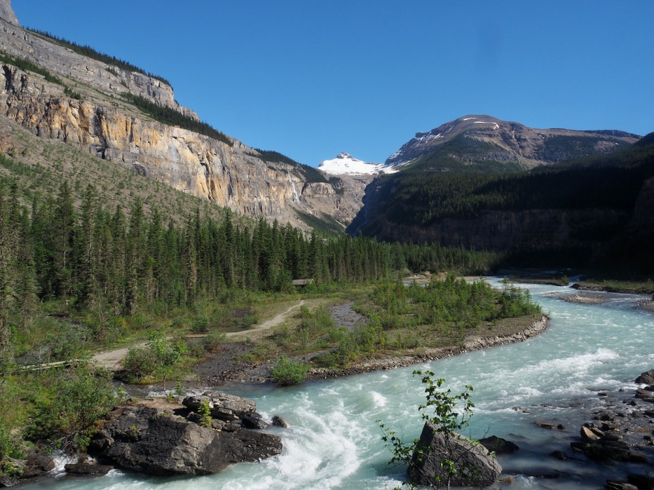
The view up the canyon to Whitehorn Mountain 
Dinner on the banks of the Robson River, Whitehorn campground

Telephoto view of Whitehorn Mountain from camp
Whitehorn Camp to Emperor Falls Camp:
This is the toughest part of the trail, gaining 518 m / 1700 ft over 5 km / 3.1 mi. However, the relentless switchbacks aren’t so bad when you’re hiking through the Valley of a Thousand Falls. There are falls everywhere—endless ribbons of water gracefully drop down sheer-sided walls, and enormous cascades plummet right next to the trail.
We stop at the Falls of the Pool overlook for a much needed break. Like on other parts of the trail, there is a great little hand-crafted bench strategically positioned to drink in the views.
A little further along, we come to to the turnoff for Emperor Falls. A 200 m path leads to the largest waterfall along the trail. We’re hot and tired but are soon rewarded by the refreshing mist of the falls. The thundering water is incredibly loud and it’s irresistibly scary to be so close to such a force of nature. Don’t miss this short detour!
Back on the main trail, it’s another 2 km to Emperor Falls campground—our lunch stop. I am blown away by the beauty of this small campground. Tent pads line the edge of the rushing Robson River and pyramid-topped Mt. Robson commands the skyline.
If you can’t get a reservation at the popular Berg Lake campground, I think Emperor Falls would be a great option. It’s quiet, scenic and only three flat kilometres from the south end of Berg Lake.

Hiking out of Whitehorn camp. It’s Mike’s birthday today. 
Elegant waterfalls grace the walls of the Valley of a Thousand Falls 
The birthday boy climbing the switchbacks 
A look back toward Whitehorn camp on the canyon floor 
There are many views of Emperor Falls along the trail 
Emperor Falls viewpoint with Mount Robson above 
Lunch stop at the Emperor Falls campground
Emperor Falls Camp to Berg Lake Camp:
Excitement builds on the final approach to Berg Lake. It’s flat, open terrain with expansive views. The trail builders have carved an impressive path on the side of a rockfall that travels above a large gravel plain crisscrossed with dozens of streams.
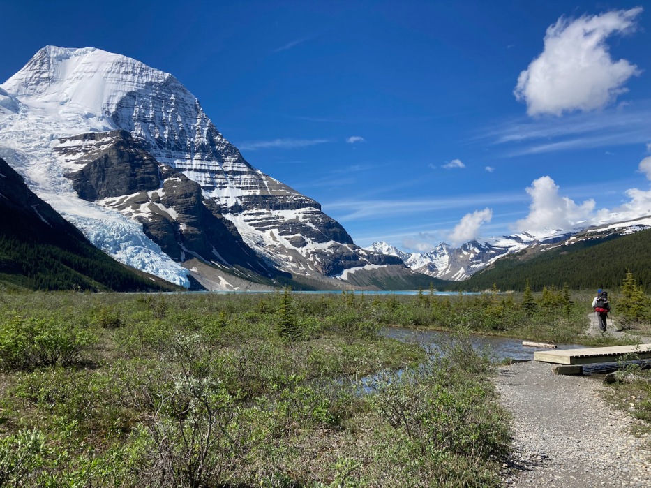
Soon we get views of Mist Glacier and see a small speck of crazy turquoise Berg Lake. The panorama unfolds with Mount Robson and Rearguard Mountain, intersected by blue-tinged Berg Glacier, towering above the lake. Hearing the glacier ice calving and plunging into the lake is icing on the cake.
Berg Lake has two campgrounds directly along its western shore. The first is Marmot, 19 km from the trailhead, at the south end of the lake. It has seven tent pads and is very serene. Berg Lake camp, our home for two nights, is 2 km further along and is the largest camp on the trail. It’s a stunner with its head on view of the Berg Glacier and Mount Robson. The camp’s “luxe” amenities— benches, picnic tables and a day use cabin—make it very comfy.
The camp’s tent pads are mostly occupied, but it doesn’t feel crowded. For relatively more seclusion, I recommend the first few tent pads approaching the camp or the ones at the far end of the camp beyond the bridge.
We spend our “free” day exploring the Toboggan Falls-Hargreaves Lake loop. It’s my favourite day of the trip and I’ll devote a separate post to this beautiful hike.

First views of Mist Glacier 
Along the rockfall path approaching Berg Lake 
Just as nice going back 
The south end of Berg Lake near Marmot camp 
Dinner on “the beach” at Berg Lake camp 
The morning view is equally glorious
Berg Lake camp to Rearguard and Robson Pass Camps:
As there is no availability at Berg Lake for a third night, we pack our stuff and hike to Rearguard campground, only one kilometre away. Although this is a tad cumbersome, it’s interesting to see anther camp. I like Rearguard; it is compact, peaceful and we score a tent pad with an awesome view.
We spend the morning exploring the trail to the toe of Robson Glacier and take a dip in Adolphus Lake (both are easy day hikes). Our plan to hike up to the Mumm Basin viewpoint is waylaid due to rain (next time). The signature day hike of the region Snowbird Pass is closed in early summer due to caribou calving (another reason to return).
On our way to Adolphus Lake, we pass by Robson Pass camp, the last campground along the trail at kilometre 23. It too looks lovely despite the gloomy skies. Bottom line is that you can’t go wrong with any of the campgrounds along the Berg Lake trail.
View from the turnoff to Rearguard camp 
Our beautiful tent pad at Rearguard camp 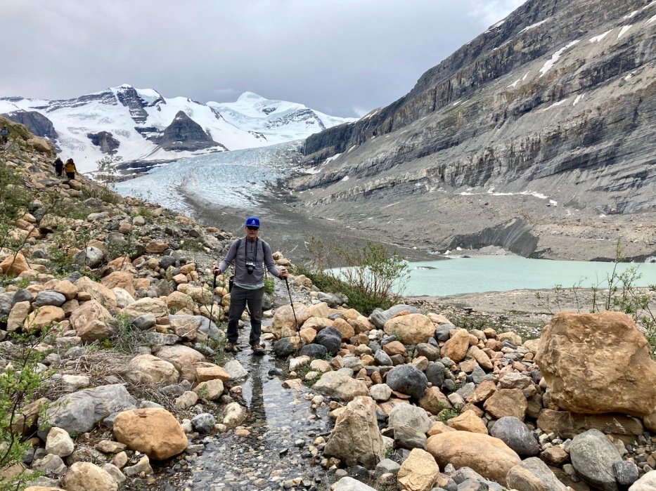
Exploring the trail to the Robson Glacier toe

Tent pads along creek at Robson Pass campground 
Rearguard Mountain from Adolphus Lake
Planning Details
- All campsites need to be reserved in advance. The Berg Lake Trail is extremely popular and you need to be on this as soon as reservations open through Discover Camping. This year, reservations opened on March 1 and the spaces were fully booked for July and August within minutes. If you are flexible, cancellations come up but you need to check Discover Camping frequently.
- Trail details including distances and elevation gains, maps, and campground facilities can be found on the Mount Robson Provincial Park website.
- Mount Robson Provincial Park is located in eastern British Columbia, near the Alberta border and adjacent to Jasper National Park. Closest hotel and food options are in the town of Valemount about a 20-minute drive from the park. It’s a good place to overnight before the hike.
- Like all backcountry hiking/camping trip you must be prepared with the essentials of food, shelter, first-aid, clothing for all types of weather, and appropriate hiking shoes/boots. Water is plentiful along most of the trail but it needs to be treated. It’s bear country, so carry bear spray/noise makers. The mosquitoes were bad during our trip in late June. Sun protection is essential on this largely exposed trail.

Here’s a sneak preview of the scene along the Toboggan Falls-Hargreaves loop—my next blog post.
Update: The Berg Lake trail is currently closed due to damage sustained by flooding. It is not scheduled to open until at least August 5, 2021. Please check the B.C. Parks website for most current information.

I can certainly see why there is hype about this trail. The photos are breathtaking!
LikeLike
Pingback: The Rockwall Trail: Kootenay National Park, British Columbia | Writes of Passage
Squeeeee this makes me sooo excited Caroline! I have reservations for this hike at the end of our next trip to the Rockies in August. I hope we have weather half as nice as you had! I am sooo excited for this one.
Did you see that lots of hikers had to be evacuated after you went? I really hope the trail re-opens for when we visit.
LikeLike
Oops. I should have read this comment before your one on my latest post. I’m very excited for you guys!!! Honestly, it is one of the most beautiful places I’ve ever visited. You will love it. Yes, we were super lucky with the weather and our timing just before the heat wave/flooding. I thought that I read it opens today? Fingers crossed that the weather, wildfires etc behave for your visit. I look forward to reading your report.
We are reserved for the Rockwall hike on Tuesday but I suspect the conditions won’t be ideal with the haze from fires.
LikeLiked by 1 person
Yeah, I am worried about the fires with all this heat. Especially when they have started so early!
I hope you have a good time on the rockwall though. I can’t wait to see your photos!
LikeLike
Pingback: Toboggan Falls-Hargreaves Lake loop: Berg Lake day hike | Writes of Passage
I am speechless, Caroline. What incredible beauty this landscape holds. The colour of the lake is almost otherworldly. It is exactly the way I would imagine spending a birthday. And like you point out, even if one can hike fast, why would one ever want to hurry in a landscape like this?
LikeLiked by 1 person
Thanks Jolandi. We only met a few other hikers who were spending five days on the trail (most just spend 2-3 days). It was such a pleasure immersing ourselves in that gorgeous landscape and not feeling rushed. We are grateful that we have the time to do this.
LikeLiked by 1 person
That particular milky-blue of the lake feels very British Columbia. Happy to hear traveling around the area is open once again. Wishing you wonderful summer journeys.
LikeLiked by 1 person
Thank you! We are taking full advantage of exploring our province this summer and Berg Lake was a great start. Our biggest concern is the heat and dryness fuelling our wildfires. So sad what is happening with climate change.
LikeLiked by 1 person
I know! Here too, every summer there is the repeated sorrow of wildfires. I’ve already witnessed three of them this year.
LikeLike
Beautiful! This trail was our first experience of the Rockies and it blew us away – we’d love to go back again (it’s been 14 years!) and your photos just ignited that desire again! We camped at Emperor Falls on our first night and it was lovely – I remember waking up to a very frosty September morning!
LikeLiked by 1 person
I’m guessing that it wasn’t as difficult securing a reservation 14 years ago! I was so impressed with the scenery on the entire trail. As I mentioned in the post, I loved Emperor Falls campground and would definitely consider staying there next time. The riverside location is simultaneously peaceful and over-the-top dramatic. Speaking of the river, did you see that it flooded and the trail was/is closed? The photos on the news of the Whitehorn bridge being pummelled with water are scary. Hikers had to be airlifted out.
Hope you’re getting in some epic hikes this summer. Back to the Chilcotins? We’re off to the Rockwall next week.
LikeLiked by 2 people
It was definitely much easier in 2007 – we just walked into the visitor centre and booked our campsites the day before (mind you, it was mid-September)! That would simply be impossible now. I heard about the flooding though I haven’t seen any photos or read anything else about it – it sounds bad! The bridge in to Whitehorn used to be a wobbly suspension bridge – is it still the same?
Enjoy the Rockwall – look forward to reading your thoughts. Yes, we’re heading back to the Chilcotins the same week – flying in to Lorna Lake as you did. Looking forward to it!
LikeLiked by 1 person
I’m so excited for you! I think about our Chilcotin trip starting at Lorna Lake (and the float plane trip there) all the time. Enjoy the trip!
The Whitehorn bridge seemed pretty solid when we were there a few weeks ago. They must have improved it since your visit.
LikeLike
mind blown. This is epically beautiful. What an incredible place to spend time, peaceful, majestic.
LikeLiked by 1 person
I was blown away. I love living in coastal B.C., but this trip reminded me how truly majestic the Rockies are.
LikeLike
Thanks, Caroline. I’ve been in the area, but never in the Park. Beautiful, and I’ve made note- it’s now on my list for next visit north of the border!
LikeLiked by 1 person
Hi Mike! This short, not super challenging route packs so much incredible scenery. I was totally impressed. I hope you get to visit and in the meantime are doing some outdoor adventures in your neck of the woods.
LikeLike
These scenes remind me in so many ways of our recent road trip views! The mountains, lakes, rivers, pines, trails …. but alas, no birthday balloons for us! This may be one of the most spectacular-looking accessible multi-day hikes I’ve seen in a while. WOW!
LikeLiked by 1 person
The scenery is over the top and you are right that it is accessible to many. Relatively speaking, this is a pretty easy backpacking excursion. Except for 4 km of nasty switchbacks, the terrain is not challenging and the campsites are spaced generously over the route. I guess that’s why it’s so popular. The reservation system is a pain but at least it controls the numbers.
LikeLiked by 1 person
This sounds/looks absolutely glorious! Beautiful photos. We are so lucky to live in such an incredible place.
Alison
LikeLiked by 1 person
Thanks Alison. One of the few good things about the pandemic is that Mike and I have visited parts of our beautiful province that I’m not sure we would have seen otherwise. We loved Mt Robson Provincial Park.
LikeLiked by 1 person
AMAZING!! I cannot wait until I can visit Canada, I have only been a couple times in my life, but now that I am a hike loving adult I know I would appreciate this beautiful country so much more.
LikeLiked by 1 person
There are endless hiking opportunities in many parts of Canada. I’m sure you’ll have a great time when you visit.
LikeLiked by 1 person
Happy Belated Birthday to Mike, I hope you guys had a fun time celebrating it. I can easily see why Mount Robson Provincial Park should definitely be on anyone’s Canadian Rockies trip itinerary as it features just about every possible natures marvel! Mount Robson is a truly striking looking peak, and if I remember correctly, sometime last year, someone discovered a new line on Mount Robson Emperor Face which is known as one of the most cherished alpine prizes in North America. I have to say that your fifth photo caught my eye right away -cedar trees are strong and beautiful. Thanks for sharing and have a nice day 🙂 Aiva xxx
LikeLiked by 1 person
Hi Aiva! Impressive! You are really up on your Canadian climbing facts. I was looking up at that north face of Mount Robson shaking my head about how it could possibly be climbed. It’s so steep and imposing; I was thrilled just to look at it. The cedar trees were a nice surprise. I didn’t expect to see such a lush forest. I learned from one of the interpretative signs that the forest developed due to the massive presence of Mount Robson that catches the rain/snow.
LikeLike
A multi-day backpacking trip to Berg Lake definitely sounds (and looks!!) like a fantastic way to celebrate the reopening of travel in your province and Mike’s birthday! The views of the mountains, lake, and waterfalls were probably great motivation to continue onwards. That’s awesome that there are such scenic picnic spots along the trail. P.S. I love that there are two balloons on Mike’s backpack to signal that it’s his birthday!
LikeLiked by 1 person
It all came together for us and our timing was great—long days, mostly great weather and just before the heat wave struck. I just found out that the trail was evacuated on July 2 due to flooding caused by snow melt from the high temps. Crazy! I had to do something for Mike’a bday and the balloons were easy to carry (I got him new hiking poles for his gift–came in handy).
LikeLiked by 1 person
How fantastic. Awesome information and photos. Perhaps you should be writing guide books? Cheers!
LikeLiked by 1 person
Thank you! Funny, one of my dreams was to write for Lonely Travel travel guides.
LikeLike
Oh my goodness! Incredible scenery! And what fantastic spots to pitch your tent and eat meals. Sounds like an amazing trip!
LikeLiked by 1 person
It has been on our hit list for a few years and we were so happy that we managed to get reservations.
LikeLiked by 1 person
Looks so amazing! great that you and Mike are taking advantage of Beautiful BC.
Your descriptions are beautiful too. 🙂
LikeLiked by 1 person
Thanks Jackie. It was such a great trip. We are taking advantage of travel B.C.–off to Kootenay National Park in a couple of weeks. Have you been out on the beaches? I can’t believe how warm the water is so early in summer. Let me know if you’re out this way and maybe we can take a dip or a hike.
LikeLike
Wow…wow.. stunning views! Awesome pictures!!
LikeLiked by 1 person
Thanks Jyothi! It’s a spectacular park.
LikeLiked by 1 person
Holy cow this looks gorgeous!!!
LikeLiked by 1 person
That’s a great way of describing it Pam! Hope you’re getting out on some hikes.
LikeLiked by 1 person
Yes! Tons over the past week. Let me tell you, I’m EXHAUSTED. But happy, super happy 😀😀
LikeLiked by 1 person
Absolutely glorious photos!!! Those blues are stunning!!
LikeLiked by 1 person
Aren’t they!? I’ve seen a lot of glacial lakes but I think Berg holds the title for most vivid colour.
LikeLiked by 1 person
Yes, they looked genuinely awesome! 🙂
LikeLike
So beautiful. What an amazing walk! Thanks for sharing
LikeLiked by 1 person
So glad you enjoyed the post!
LikeLike
Canada is so unbelievably beautiful.
LikeLiked by 1 person
Yup! I’m lucky to be living here. Thanks for visiting!
LikeLike
Wow, those turquoise lakes with the snow covered mountains in the background is just picture perfect! And you had such beautiful views! Love the balloons on Mike’s back (happy belated birthday 🎈). Oh yes, and love those benches … just melt into nature.
Truly spectacular – looking forward to your next post.
LikeLiked by 1 person
Thanks so much! Like I said in my post, I had read and heard so much about how great this hike is that I had to keep my expectations in check. But it is everything and more than you see in the photos. We were also very lucky with the weather, which always helps. The benches are a delight. I loved turning a corner and seeing a bench with a perfect view. The park rangers have done an awesome job.
LikeLiked by 1 person
What a way to celebrate the reopening of travel indeed, and happy belated birthday to Mike! It’s funny how he had to hike with those two balloons. Yet again, I’m stunned by Canada’s natural beauty. Those towering peaks, turquoise lakes, and lush forests on a sunny day are just so breathtaking. And I can almost feel the crisp air through your photos. Marvelous!
LikeLiked by 1 person
Thanks Bama. Although international travel probably won’t be happening for us this year, I feel super fortunate to be exploring more of B.C. The scenery was out of this world and I look forward to two more multi-day hikes in the coming months. Mike was a good sport about the silly balloons. I figured it was about the lightest thing I could bring with me. It made for good trailside conversation with other hikers.
LikeLiked by 1 person
Wow, fantastic!!Sent from my Galaxy
LikeLiked by 1 person
You had told me how amazing it is and it totally lived up to expectations. Incredible!
LikeLike
What a great landscape, it must be exhilarating to spend time with such a view around you!
LikeLiked by 1 person
Absolutely! We were lucky to get mostly good weather so hiking and camping with such views was better than staying in a luxury hotel (for me anyway).
LikeLiked by 1 person
Wow, the hike has amazing views. For some reason I always thought that the entire hike in was in a thick forest with no views, but you’ve proven me wrong – thankfully. Actually even the forest looks great with the big cedars. The valley of a thousand falls sounds incredible. You were probably there at the right time for the waterfalls too. Robson is really a majestic mountain isn’t it. Okay, it’s definitely on our must-do list. Happy birthday Mike, did you bake him a campfire cake? Maggie
LikeLiked by 1 person
Most of the hike is open, which I love since I usually spend my time immersed in the deep forest around here. The Valley of a Thousand Waterfalls is right up there for me in terms of favourite section of the hike. It’s super dramatic. Ya, for sure we were there at the peak time for waterfalls, and with the rapidly rising temps, the river was flowing furiously. On the way down, a small portion of the trail was flooded (easy detour though). I really want to return to hike Snowbird Pass which was closed for caribou calving season.
No cake for Mike but we indulged in our favourite dehydrated dessert—creme brûlée (with a few musical candles stuck in the middle).
LikeLiked by 1 person
What a stunning walk! Thanks for the inspiration. Mel
LikeLiked by 1 person
I’m glad you enjoyed it. Thanks for reading!
LikeLiked by 1 person