

Skyline Ridge Trail, Squamish—C.Helbig
My friend Eva (the Swedish mountain goat) pushes me slightly beyond my hiking comfort. That’s a good thing, and inevitably it turns into an epic day. This time she introduced me to the Sky Pilot Valley—Skyline Ridge loop, a backcountry route accessed from the top of the Squamish Sea to Sky Gondola (about an hour from downtown Vancouver). During our roughly 8-hour, 23ish km hike we scrambled up rocky slopes and snow chutes, traversed exposed ridges, and clung to branches as we “tarzaned” our way down precipitous terrain (plus a bit of easy stuff too). It was exciting, challenging, fun, and the scenery was out of this world.
The photo below, taken at the Sea to Sky Summit Lodge (the start and end of our hike) shows where we went. See the sharp peak above my head (I’m the short one)…the one that looks dauntingly far away? That’s Copilot. We hiked to the base of the triangular peak.

Eva (the mountain goat) and I pose beneath Sky Pilot and Copilot peaks.
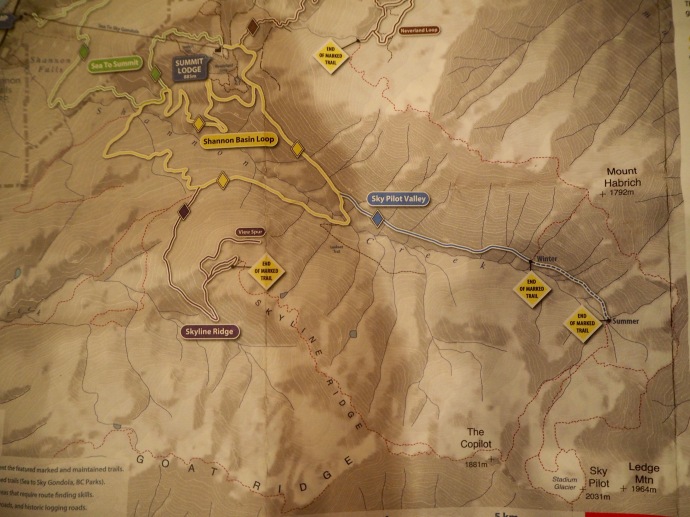
Backcountry map Sea to Sky Gondola
From the lodge, we headed out on the Shannon Basin Loop (yellow on map) and turned onto the Sky Pilot Valley Trail (blue). This is a relatively easy part of the hike as you slowly gain elevation. Much of this section is through the forest, and views only begin to open up near the end of the officially marked trail approaching the treeline below Sky Pilot. From there, you have gorgeous views of Mt. Habrich on the other side of the valley, and Sky Pilot ahead.

Mt. Habrich from Sky Pilot Valley—C.Helbig
Beyond the marked Sky Pilot Valley Trail, we followed the mountaineering trail (dotted red on map) up towards Copilot. It’s not really a trail, but there are a few cairns and ribbons on the open and rocky slopes. The trail requires agility and navigation skills, and it takes you to seriously beautiful terrain.

Start of rocky slope leading to Copilot base—C.Helbig

View of Mt. Habrich
As the relentless uphill scrambling continued, the views just kept getting better. On the one side is Mt. Habrich and the valley we had just hiked up (photo above), and in front of us, the Stadium Glacier and craggy sub-peaks (photo below).

Eva studying the map at our perfect lunch stop—C.Helbig
We found the perfect lunch spot next to a shimmering turquoise pond, one of my favourite places along the route. I could have happily sat there for several hours, and was under the impression that we had reached our high point. Not a chance.

Stadium Glacier, beneath Sky Pilot/Copilot—C.Helbig
We had another section of rock, loose rubble, and snow to contend with. The cairns and ribbons had all but vanished and this section is particularly steep (a few parts requiring all fours). We plotted a zigzag course towards the ridge at the base of Copilot. I didn’t have my camera out for this, which is a shame, but my instinct was self-preservation.

Along the base of Copilot—C.Helbig
I was both relived and a tad anxious as we finally got to our high point, just below the dark grey peak of Copilot. It’s fairly exposed with some nasty drop-offs. Eva kept asking me, “You OK?” I was so focussed on where and how I was stepping that I wasn’t doing a lot of talking. At one point, when I felt I had a bit more of a buffer around me, I pulled out my camera for a shot of the beautiful Skyline Ridge below us. I tried not to worry about how we were going to get down there. It isn’t obvious, and I was very glad that Eva had scoped this out on previous hikes.

View down to where we were heading next: Skyline Ridge—C.Helbig

View down from a different angle—C.Helbig
So here comes the Tarzan part. Sadly, I don’t have any photos of us swinging from branches, but the image below shows our route off Copilot. See the large clump of trees clinging to the side of the mountain? Yup, that’s the route. It’s dreadfully steep, but there are tree branches and roots to grab onto (Eva’s gardening gloves are not just a fashion statement).

View back to Copilot and where we came down through the trees—C.Helbig
I admit, I was happy to be through the Tarzan section and on more forgiving terrain. Skyline Ridge is magnificent. Its pretty meadows are dotted with little ponds and the mountain views in all directions are fabulous. There are great ocean views further along the trail. The next four photos are all taken along the “unmarked” Skyline Ridge (before getting to the official trail marked in purple on the map). Route finding here is more straightforward and the occasional cairns and ribbons add extra confirmation. Overall, It was my favourite part of the loop.

Skyline Ridge Trail has many pretty ponds—C.Helbig

Another view of Mt. Habrich from Skyline Ridge—C.Helbig

Skyline Ridge Trail looking down to Squamish Valley—C.Helbig

Skyline Ridge looking to Howe Sound—C.Helbig
Much of the marked Skyline Ridge Trail (except for the view spur) is through the forest with limited views. It’s a bit anticlimactic after the WOW hiking we had just done. We booted it down the trail and back along the Shannon Basin Loop where a refreshing rest stop at icy cold Shannon Creek was just what we needed for the final leg back to the lodge.

The Summit Lodge at Sea to Sky Gondola—C.Helbig
What a great way to end an epic hike—on a killer patio at the Sea to Sky Summit Lodge. Thanks Eva for introducing me to what we now simply refer to as “The Loop”.
IF YOU GO
This hike is amazing, with a great variety of outstanding scenery, but I don’t recommend it for inexperienced hikers and people unfamiliar with the area. It is long, challenging, and not without its hazards. It requires route finding skills (do not rely on my general route description). Budget at least 8 hours and check the gondola schedule for time of last ride down. I recommend the direction described above as the loose, rocky section from Sky Pilot Valley to Copilot is easier/safer going up than coming down.
My favourite part of the hike (beyond the marked Skyline Ridge Trail) would make a great out and back hike of up to 24 km (7-8 hours). The path is fairly easy to follow beyond the marked Skyline Ridge Trail, though it peters out from time to time. You can turn around at any point, but the scenery as you approach Copilot keeps getting better. There is nothing scary on this section, it’s just long and steadily uphill. Update: I did the out and back version a few weeks after writing this post. Check it out here.
There are lots of other hikes, for all levels, accessible from Sea to Sky Gondola in Squamish (about a one hour drive from downtown Vancouver). Check out their website and my earlier post about hiking Al’s Habrich and other trails.

Pingback: Al's Habrich ridge trail - Squamish - A walk and a lark
Pingback: 100th Post: Ten Places that have “Stuck with Me” | Writes of Passage
Pingback: Late Summer Hiking at its Best: Garibaldi Provincial Park’s Opal Cone | Writes of Passage
Pingback: Fall Colours: Hiking Skyline Ridge Trail, Sea to Sky Gondola | Writes of Passage
How very gorgeous, especially your picnic spot. Love the way this post is written, with humor and of course stunning landscape photographs! Sounds strenuous but worth it.
Peta
LikeLiked by 1 person
Thanks Peta, I think the humour comes out when I’m a tad nervous. This hike was so good that the endorphin high stayed with me for the rest of the week (and so did the sore hips).
LikeLike
Hike followed by MASSAGE 🙂
LikeLiked by 1 person
Wow. What a gutsy ‘walk’. You sure have a lot of drive, never mind conditioning.
LikeLiked by 1 person
It’s a good thing that I have my friend Eva to push me on these type of hikes. Hope all is well with you guys.
LikeLike
Wow, epic is the word! I’m happy to have done the hike via your captivating account of it. You must have felt an amazing sense of achievement. And beautiful photos. I love BC!
Alison
LikeLiked by 1 person
My hips are still feeling the epic up and downhill! It was amazing and I hope to do it again. I love BC too…I just took a dip in Whyte Lake (above Horseshoe Bay). The ocean is too cold for me. Have a good weekend!
LikeLiked by 2 people
Oceans lakes rivers – it’s Canada! – it’s ALL too cold for me 🙂
Good weekend to you too.
A.
LikeLiked by 1 person
Wow, incredible! This is gonna have to be added to my to-do list.
LikeLiked by 1 person
Happy to give you more info when you’re ready to knock it off your list.
LikeLike
Wow Caroline I really am going to have to try and get myself to Canada one day. Spectacular,Well done on reaching the top. it looks amazing and you have done a great job with the photos and all the information. I might pin this on my Pinterest account over the week end. I’ll let you know when I do. Also I phaffed about a bit trying to work out the star vote thingy. So it might show multiple votes.
LikeLiked by 1 person
Thanks Louise, you are always so supportive. I’m not sure about the star thingy either, but thank you! I do hope you get to my part of the world, and I get to yours. This hike really was incredible and I’m grateful for the good friends I have who share my passion (and help me through the scary stuff).
LikeLiked by 1 person
Yes, yes the scary stuff.
LikeLiked by 1 person
Pinned this to new Board “Other Mountains”, Pinterest Account the same name as my blog. I will pin more slowly. So much to do….
LikeLiked by 1 person