
View of Jervis Inlet coming down Mt. Troubridge—C.Helbig
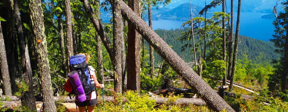
My friend Morag and I learned about the 180 km Sunshine Coast Trail—Canada’s longest hut-to-hut hiking trail— at the Vancouver Mountain Film Festival. Eagle Walz, the trail’s co-founder and president of the Powell River Parks and Wilderness Society (PRPAWS), enticed us with images of spectacular mountain and coastal vistas, old growth forests, secluded lakes and the promise of a real roof over our heads (for free!) at the end of each hiking day. We were hooked!

Well-maintained trails and great signage on the Sunshine Coast Trail—C.Helbig
We just returned from sampling a 42 km section of the Sunshine Coast Trail (SCT) and it was every bit as good as Eagle described (despite the aching thighs). One of the many great things about the Sunshine Coast Trail (SCT) is that if you don’t have the time or energy to do the entire 180 km, it’s easy to access sections for shorter multi-day hikes or day hikes.
The trail stretches from Sarah Point, north of Lund, to Saltery Bay on British Columbia’s northern Sunshine Coast with 13 huts and 20 tent-sites, all built and maintained by volunteer labour of PRPAWS and support of community groups. We selected the section from Lang Bay (Lois Lake) to Saltery Bay via Mt. Troubridge, the trail’s highest point, and did it as a 4-day, 3-night trip.

Our route: Lang Bay to Saltery Bay (at lower right of map) www.sunshinecoast- trail.com
DAY 1: Lois Lake Trail to Golden Stanley Hut
- Approx. 8 km (3 hours), minimal elevation gain at the end, approaching Golden Stanley Hut.
Lois Lake, Sunshine Coast Trail—C. Helbig
If you’re coming from Vancouver, there’s travel time and logistics involved (about 4.5 hours via road and 2 ferries) so it’s nice that the first day of hiking isn’t too long or difficult. We got to Saltery Bay at 2pm and left our car at the overnight parking ($5/night) just to the right of the ferry terminal. Apparently it’s not difficult to hitchhike to Lang Bay (the access point to Lois Lake), but we decided to play it safe and reserve a Powell River taxi in advance. That worked out well, and not only did the driver take us to Lang Bay, but kindly drove us up the logging road almost to Lois Lake trailhead (we had anticipated walking several km along a boring road).


It wasn’t hard to spot the distinctive red markers and large wooden signs for the SCT, and we were soon ambling along the pretty Lois Lake trail. The trail weaves in and out of the forest but has plenty of lake access if you’re in need of a swim. We, however, were on a mission to get to our first overnight stop, the Golden Stanley Hut.
There it is, our comfy digs for the night, which we shared with Keith, Sue, and Bruce, intrepid hikers who were doing the entire 180 km. The Golden Stanley Hut has a fully enclosed upstairs loft with room for about 10 people.

The Golden Stanley Hut, Sunshine Coast Trail—C.Helbig
I don’t normally include photos of outhouses but this one, nestled in the forest with its rock-lined path and pretty door is really skookum! Best of all, it didn’t smell.

The outhouse at Golden Stanley Hut—C.Helbig
DAY 2: Golden Stanley Hut to Mount Troubridge Hut
- Approx. 13 km and 1100 m elevation gain (5-6 hours).


Getting our vitamins along the trail
This was arguably our toughest hiking day with a continuous uphill grunt, but it was also my favourite day. We loved the much needed rest stop at the Carved Chair Campsite. When we finally got to Elephant Lake, 3+hours uphill, we gorged ourselves on blueberries and took a refreshing dip.
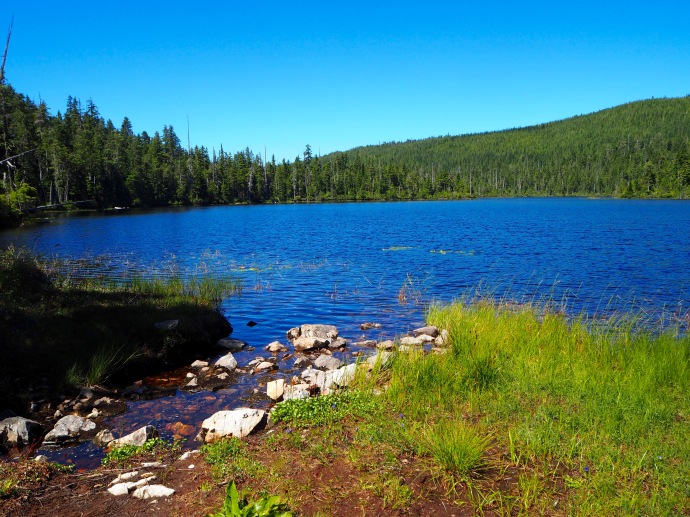
Elephant Lake, the perfect rest spot enroute to Mt. Troubridge—C.Helbig
Invigorated by our rest at Elephant Lake, the trudge up to Mt. Troubridge Hut wasn’t as bad as we had expected. Plus, all the pain was forgotten when we saw the amazing Douglas fir cabin, and discovered that there was another great swimming spot just steps from our lovely abode.

Gorgeous Mount Troubridge Hut on the Sunshine Coast Trail—C.Helbig
The Troubridge Hut is absolutely stunning. The log shell was manufactured and assembled in Powell River and then flown up in pieces by helicopter. Once again we were happy to share this next hut with Keith, Sue and Bruce who had hightailed it out of Golden Stanley before we were even up.

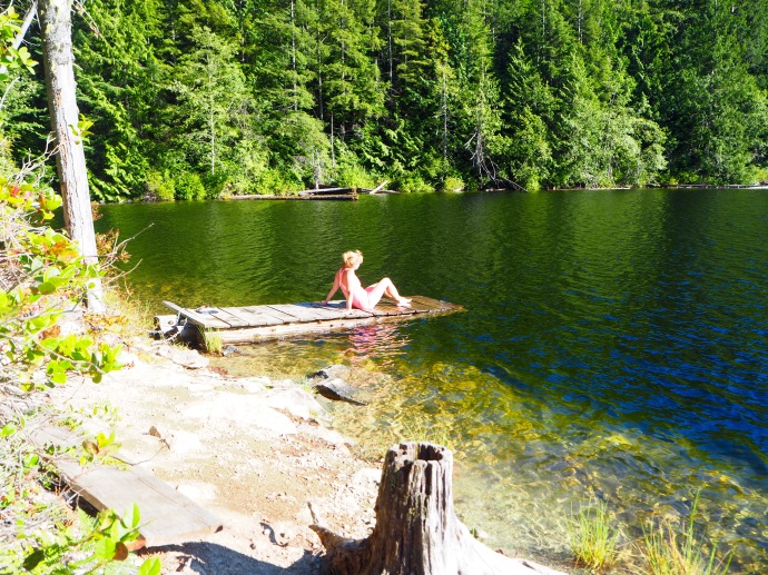
The lake just steps away from the Mt. Troubridge Hut—C.Helbig
Isn’t this lake and little dock a sight for sore feet, backs, thighs…! Not knowing about this gem before our arrival made it even more special.
DAY 3: Mt.Troubridge Hut to Rainy Day Lake Hut
- Approx. 11 km and about 2oo m gain to Troubridge summit, then 850 m loss to Rainy Day Lake (5 hours).
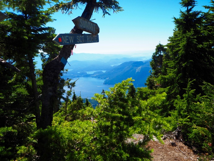
A few more steps to the top of Mt. Troubridge (1300m)—C.Helbig
Today was all about the views, a lot of thigh-burning downhill (with a little unintended uphill), and another beautiful swimming lake.
One of our biggest surprises on most of our route, but particularly this section, was the number of tiny frogs (Morag thinks they’re toads) we saw on the trail. They were everywhere, scampering when they felt our thunderous steps. We expected deer, elk, bears…but frogs?

Great views coming down Mt. Troubridge—C.Helbig
Another surprise was the lack of people on the trail. On this section we encountered no other hikers until we got to Rainy Day Lake Hut; on other days we met less than a handful. I’m selfishly glad that the SCT still seems to be a well-kept secret.

Views open up “thanks” to logging activity—C.Helbig
We had been so spoiled by the awesome trail signage that we rarely consulted the trail guide. In our complacency, we marched right past an important turnoff at km 166 and happily wandered down a logging road until we realized that we hadn’t seen any signs. We backtracked up the steep, hot road looking for where we had gone wrong. Even with the detailed instructions it took us some effort to find the overgrown turnoff (it was the only place on our entire route where signage could be improved).

Rainy Day Lake Hut—C.Helbig
With the lure of another beautiful lake, we decided to take the .5 km detour to the Rainy Day Lake Hut. The hut commands a fabulous spot on top of a bluff with views to the lake.
We shared this hut with friendly Sam and Mark who pitched their tent on the ground floor, worried that they had seen hornets in the sleeping loft. Morag and I took our chances and came away unscathed, save for a few mossy bites. (This hut is not fully enclosed like the Troubridge Hut.)
Awesome Rainy Day Lake just below the hut—C.Helbig
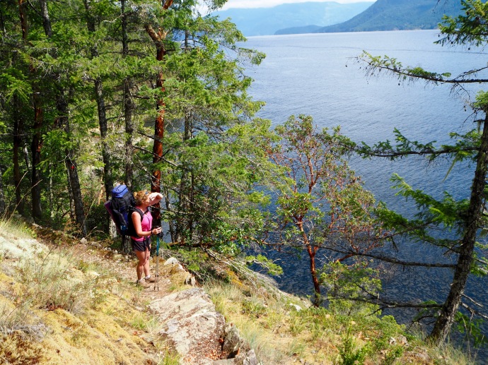
DAY 4: Rainy Day Lake to Saltery Bay
- Approx. 10 km, with an elevation loss of about 450 m to Fairview Bay then lots of ups and downs as the trail skirts the coast (4 hours).
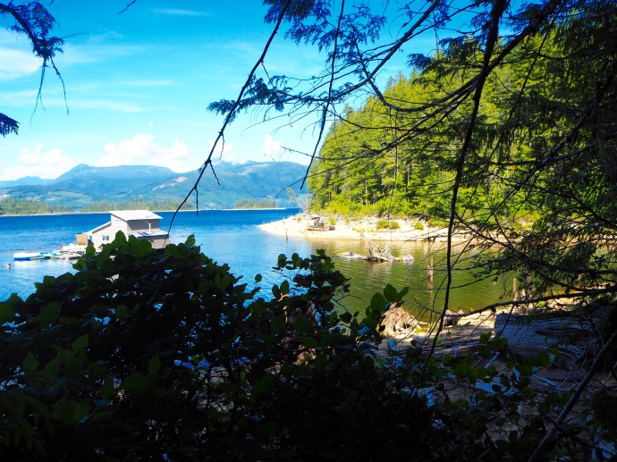
Fairview Bay section of Sunshine Coast Trail—C.Helbig
The Fairview Bay section of the SCT is just glorious and I wish I could have spent a full day and night at Fairview Bay Hut relaxing and swimming and enjoying the beautiful coastal scenery. The hut is only 2 km from the Rainy Day Lake Hut but the experience is completely different. If you don’t stay at Fairview Bay, make sure you stop there for lunch or a break and don’t rush this section of the trail.
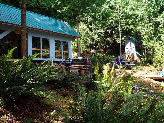
Fairview Bay Hut on Sunshine Coast Trail—C.Helbig

View from Fairview Bay Hut—C.Helbig
The Fairview Bay Hut sits right on the coast with a great bay for swimming, and views over the Jervis Inlet. The photo on the left is a view directly from the hut. Folks we met along the trail told us they had seen humpback whales. It’s an awesome spot!
From the hut, it’s a gorgeous 7 km hike to Saltery Bay, the southern terminus of the SCT. Don’t be fooled though, it’s not a flat, coastal walk. The trail undulates up and down continuously, winding its way through the forest and across rocky bluffs.

Fairview Bay section of Sunshine Coast Trail—C.Helbig
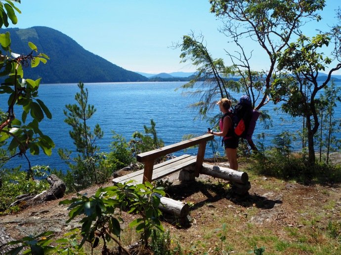
Fairview Bay Trail only a few km from Saltery Bay—C.Helbig
The photo above was taken only a few km from the end of the trail and Saltery Bay ferry terminal, but it felt a millions miles away and wonderfully peaceful. It was a great way to end our first Sunshine Coast Trail adventure. We can’t wait to return and hike the other sections!
IF YOU GO
The Sunshine Coast Trail website is a great resource with maps, information about the trails, huts, and how to get Powell River/Sunshine Coast.
The Sunshine Coast Trail Guidebook by Eagle Walz is a step-by-step description of all the trails that make up the SCT. It’s a must-have if you’re going to hike the SCT. Information on how to order can be found on the website above.

Glorious! Putting this on a wish list!
LikeLiked by 1 person
It’s really lovely, and there are many sections to select from. We hope to do another piece this summer. The website and guidebook mentioned above are very helpful.
LikeLiked by 1 person
How long is the hike to the Summit of Mt Troubridge from the Mt Troubridge hut near the pond?
LikeLiked by 1 person
I can’t remember exactly but just consulted my SCT book and it’s about 2 km. Shouldn’t take more than half an hour (all uphill of course).
LikeLike
Beautiful scenery and beautiful photos – thanks for sharing
LikeLiked by 1 person
What a beautiful place, especially when the weather is so sunny.
LikeLiked by 1 person
Thankfully, that promising name “The Sunshine Coast” came through for us (not always the case in coastal BC). It is a beautiful place. Thanks for reading.
LikeLiked by 1 person
You’re very welcome! 🙂
LikeLike
Hi there. So happy to have found this. Planning to do this exact route this coming weekend with 2 others. I’m wondering if you had any maps/such other than the guidebook? Thanks. Sy Yunn from Vancouver.
LikeLike
Hi Sy Yunn, we printed a couple of maps from the SCT website. As I mentioned in the post, the trail is really well marked. Between the trail signs and the guide book you won’t have a problem. Just pay attention around km166. Enjoy!
LikeLike
Great article Caroline. I love the scenery in the pictures, a beautiful part of the world.
LikeLiked by 1 person
Thanks David. It’s a great spot. You should visit some time.
LikeLike
Beautiful British Columbia! What a fabulous hike. I had no idea this even existed. Love the cabins.
Alison
LikeLiked by 1 person
It’s a well-kept secret.Having the cabins is so much nicer and easier than lugging a tent!
LikeLiked by 1 person
Once again Morag and Caroline, blaze amazing, new territory for future return with their groupies we hope! Looks gorgeous, thanks for the great eye candy and informative intel.
Trish
LikeLiked by 1 person
Ya gotta come with us for the next segment!!! So much fun.
LikeLike
Thanks Caroline – it looks lovely – looking forward to doing some day hikes there.
LikeLiked by 1 person
You’ll love it! I’m looking forward to checking out the northern section (also a little less up/downhill!)
LikeLike
You had a wonderful trip!
Beautiful area!
LikeLiked by 1 person
Lions and tigers and bears, oh wait! And toads. Now we are getting somewhere.There’s the Aussie Canadian connection – we have Queensland Cane Toads. An introduced species to combat some bugs and then they took over. Fortunately I don’t live in Queensland.
All that aside, Caroline what a spectacular place. I studied the map before I read on and realised that it would have stunning views. Oh the vistas, the colours, how beautiful. It looks like lovely weather too. It is very informative post and who wouldn’t want to do the trail after seeing the post?
A couple of Aussie questions. Are the blueberries growing in the wild and you picked them? What does skookum mean?
I’m really glad the first hut has a fully enclosed loft bedroom…me and the bears, you know…
Louise
LikeLiked by 1 person
I’m still chuckling about seeing toads and no big animals!
It was a great trip and one of the few perfect weather weeks we’ve had this summer. It was nice being able to swim.
Good questions Louise. The blueberries are wild and grow prolifically along the side of the trail at higher elevations.I picked the berries in the posted photo for our breakfast…fabulous! British Columbia is a huge producer of both wild and cultivated blueberries. We also picked blackberries and huckleberries.
I thought I might get a comment about the word “skookum”. It’s a very localized Pacific Northwest word (First Nations origin) that is used in this context as “genuinely cool/first-rate” but has many more traditional meanings like strong, brave, really significant. There’s a place not too far from here called the Skookumchuck Narrows which means “strong waters”. You asked for it!
Thanks for reading so thoroughly Louise. The post is longer than I would have liked but I was on a roll and didn’t want to do it in parts.
LikeLiked by 1 person
Don’t apologise for a long post because it’s great and not that long. Thank you for the clarification on the berries and skookum is great word and the explanation very interesting.
LikeLiked by 1 person
Beautiful! Morag makes a great model:)
LikeLiked by 1 person
Yes she does complement the scenery quite nicely. Next time you need to be in the photos!
LikeLike
This was one of my top hikes so far. Great weather, well marked trails, beautiful huts and wonderful company. A must do- thanks Caroline.
Your hiking companion,
Morag.
LikeLiked by 1 person
Looking forward to the other sections with you!
LikeLike